
Regulations Amending the Metal and Diamond Mining Effluent Regulations: SOR/2018-280
Canada Gazette, Part II, Volume 152, Number 26
Registration
SOR/2018-280 December 17, 2018
FISHERIES ACT
P.C. 2018-1568 December 14, 2018
Her Excellency the Governor General in Council, on the recommendation of the Minister of the Environment, pursuant to subsection 36(5) of the Fisheries Act footnote a, makes the annexed Regulations Amending the Metal and Diamond Mining Effluent Regulations.
Regulations Amending the Metal and Diamond Mining Effluent Regulations
Amendment
1 Schedule 2 to the Metal and Diamond Mining Effluent Regulations footnote 1 is amended by adding the following in numerical order:
| Item |
Column 1 |
Column 2 |
|---|---|---|
44 |
All waters located within the area described in column 2, located approximately 15 km west of Fermont, Quebec |
The waters located within an area located approximately 15 km west of the town of Fermont, Quebec. More precisely, the area bounded by 12 straight lines connecting 12 points starting at the point located at 52°50′ 7.003″ north latitude and 67°24′37.670″ west longitude to the point located 1663.7 m to the southeast at 52°50′0.527″ north latitude and 67°23′9.420″ west longitude to the point located 99.8 m southeast at 52°49′58.858″ north latitude and 67°23′4.849″ west longitude to the point located 1041.6 m northeast at 52°50′16.401″ north latitude and 67°22′17.322″ west longitude to the point located 2931.3 m southeast at 52°49′14.652″ north latitude and 67°20′18.454″ west longitude to the point located 1116.2 m southwest at 52°48′54.699″ north latitude and 67°21′8.259″ west longitude to the point located 2600 m northwest at 52°49′28.689″ north latitude and 67°23′15.237″ west longitude to the point located 1332 m southwest at 52°49′22.360″ north latitude and 67°24′25.623″ west longitude to the point located 2752.5 m southeast at 52°48′0.645″ north latitude and 67°23′27.147″ west longitude to the point located 640 m southwest at 52°47′48.090″ north latitude and 67°23′54.322″ west longitude to the point located 2267.36 m northwest at 52°47′54.530″ north latitude and 67°25′54.901″ west longitude to the point located 1142.3 m northwest at 52°48′31.230″ north latitude and 67°26′2.164″ west longitude and ending at the point located 3355.9 m northeast at 52°50′7.003″ north latitude and 67°24′37.670″ west longitude. |
45 |
A portion of an unnamed |
A portion of an unnamed canal located approximately 15 km west of the town of Fermont, Quebec. More precisely, the 1383 m portion of the canal extending southeast from the point located at 52°47′48.090″ north latitude and 67°23′54.322″ west longitude to the point located at 52°47′20.635″ north latitude and 67°22′56.004″ west longitude. |
46 |
All waters located within the area described in column 2, located approximately 15 km west of Fermont, Quebec |
The waters located within an area located approximately 15 km west of the town of Fermont, Quebec. More precisely, the area bounded by 10 straight lines connecting 10 points starting at the point located at 52°44′14.968″ north latitude and 67°18′31.354″ west longitude to the point located 939.5 m northeast at 52°44′30.414″ north latitude and 67°17′48.213″ west longitude to the point located 1953.6 m northeast at 52°44′52.900″ north latitude and 67°16′10.857″ west longitude to the point located 441.38 m southeast at 52°44′39.901″ north latitude and 67°16′1.106″ west longitude to the point located 1547.48 m southwest at 52°43′55.611″ north latitude and 67°16′39.714″ west longitude to the point located 769.69 m southwest at 52°43′53.983″ north latitude and 67°17′20.688″ west longitude to the point located 778.84 m southwest at 52°43′32.957″ north latitude and 67°17′43.574″ west longitude to the point located 76.9 m northwest at 52°43′33.669″ north latitude and 67°17′47.500″ west longitude to the point located 667.76 m southwest at 52°43′12.872″ north latitude and 67°17′57.155″ west longitude to the point located 195.7 m northwest at 52°43′14.311″ north latitude and 67°18′7.310″ west longitude to the point located 1928 m northwest and ending at the point located at 52°44′14.968″ north latitude and 67°18′31.354″ west longitude. |
Coming into Force
2 These Regulations come into force on the day on which they are registered.
REGULATORY IMPACT ANALYSIS STATEMENT
(This statement is not part of the Regulations.)
Executive summary
Issues: ArcelorMittal Mining Canada G.P. (AMEM) is required to carry out work related to the management of tailings, new waste rock piles and process water basins associated with the expansion of the Mont-Wright Mine. The Mont-Wright Mine is an iron mine located about 15 km west of Fermont on the eastern shore of Hesse Lake and 320 km north of Port-Cartier and Sept-Îles, in Quebec.
The existing storage areas have to be expanded because the current authorized areas for storing waste rock and tailings are not large enough to maintain operations until the end of the current mine plan, in effect until 2045.
AMEM is proposing to dispose of tailings and waste rock in water bodies frequented by fish. However, section 36 of the Fisheries Act (FA) prohibits the deposit of deleterious substances in water frequented by fish, unless authorized by regulations under the FA or another Act of Parliament. The Metal and Diamond Mining Effluent Regulations (the Regulations), made under subsections 34(2), 36(5) and 38(9) of the FA, includes provisions permitting the use of water bodies frequented by fish for the disposal of mine waste.
Description: The Regulations Amending the Metal and Diamond Mining Effluent Regulations will add water bodies to Schedule 2 of the Regulations, designating them as tailings impoundment areas for the Mont-Wright Mine expansion.
Cost-benefit statement: The regulatory amendments will generate additional costs for AMEM connected with the implementation of the compensation plan to offset the loss of 63.9 hectares (ha) of fish habitat associated with the disposal of tailings and waste rock, as required by section 27.1 of the Regulations. This loss will be offset by the implementation of the compensation plan, which will result in a direct gain of 74.55 ha of fish habitat. The estimated cost of the implementation of the compensation plan is $14,000,000. footnote 2
“One-for-One” Rule and small business lens: The “One-for-One” Rule does not apply to the proposed regulatory amendments, as there is no change in the administrative costs imposed on business.
The regulatory amendments do not trigger the small business lens, as AMEM, the owner and operator of the Mont-Wright Mining Project, is not considered a small business.
Background
Metal and Diamond Mining Effluent Regulations
The Regulations, which came into force on June 1, 2018, footnote 3 prescribe the maximum authorized limits for deleterious substances in mine effluent in Schedule 4 (e.g. arsenic, copper, cyanide, lead, nickel, zinc, radium-226 and total suspended solids). The Regulations also specify the allowable acidity or alkalinity (pH range) of mine effluent and require that mine effluent not be acutely lethal to fish. footnote 4 The Regulations further require that mine owners and operators sample and monitor effluents to ensure compliance with the authorized limits and to determine any impact on fish, fish habitat and fishery resources.
The use of waters frequented by fish for mine waste disposal can only be authorized through an amendment to the Regulations by listing the water body in Schedule 2 of the Regulations. As of June 2018, 43 water bodies were listed in Schedule 2.
When a fish-frequented water body has been added to Schedule 2, section 27.1 of the Regulations require the development and implementation of a fish habitat compensation plan to offset the loss of fish habitat that would occur as a result of the use of a fish-frequented water body for mine waste disposal. The owner or operator of a mine is also required to submit an irrevocable letter of credit to ensure that funds are in place should the owner or operator fail to address all the elements of the compensation plan. The mining proponent must demonstrate that the disposal of tailings (including effluents) in these water bodies is the best approach from an environmental, technical and socio-economic perspective.
The Mont-Wright Mine expansion project
The mine has been in operation since 1975 and currently consists of an open-pit mine, an ore crusher, milling facilities, a maintenance workshop, tailings impoundment areas and waste rock piles, as well as an automated system for sending ore concentrate to Port-Cartier by train. The mining property covers a total area of 140 km2.
AMEM’s facilities are located on the North Shore in the Fermont area (Mont-Wright mining complex and Fire Lake backup mine) and at Port-Cartier (industrial complex and seaport), linked by a 420 km rail line. The annual production is approximately 24 million tonnes (Mt) of iron ore concentrate. Of that amount, 15 Mt are shipped directly as concentrate and 9 Mt are shipped as iron oxide pellets.
The total infrastructure costs for the expansion and water management project until 2045 are estimated at $458 million.
Tailings and waste rock management in the Mont-Wright Mine expansion project
The existing storage areas have to be expanded because the current authorized areas for storing waste rock and tailings are not large enough to maintain operations until the end of the current mine plan, in effect until 2045.
Expansion of the current tailings impoundment area (Hesse Tailing Pond) and construction of the process water basin (B+ Basin)
The Hesse Tailing Pond is located a few kilometres north of the mining complex and was designed to store 1 029 million cubic metres (Mm3) of tailings. On January 1, 2015, approximately 614 Mm3 of tailings were unloaded into it, and, according to the new mine plan, the current tailings impoundment area will be full in 2026, given that iron production is to increase to 30 Mt annually from 2018 to 2045.
According to the information provided by AMEM, 785 Mt of iron ore concentrate will be produced between now and 2045, which represents 1 318 Mt of tailings. footnote 5 From 2014 to the end of 2025, 493 Mt will be impounded in the optimized footprint of the current Hesse Tailing Pond, and, between 2026 and 2045, the future storage scenario should allow for the storage of approximately 825 Mt of tailings.
The Hesse Tailing Pond currently includes a settling basin (the North Hesse Basin) located west of the tailings impoundment area that is used to settle the tailings as a retention basin to receive the spring freshet and form water reserves for winter operations. With the deposit of the tailings, the basin’s capacity will diminish, so a new basin (B+ Basin) will have to be developed. The B+ Basin will be required to manage water efficiently and in accordance with the applicable regulations. B+ Basin will be developed downstream of the outfall of the tailings impoundment area and will have an initial capacity of 10 Mm3.
The total surface area of the fish habitat that will be destroyed by the expansion of the Hesse Tailing Pond and the development of B+ Basin is 62.4 ha.
Expansion of the waste rock pile sector
The Mont-Wright Mine’s existing waste rock piles were built around the perimeter of the mined pits. They were positioned to take into account the location of the ore reserves to allow for the long-term operation of the mine.
AMEM currently needs to store 1 900 Mt of waste rock between now and 2045. To do so, AMEM has proposed lengthening the existing waste rock piles around the perimeter of the pits (mainly toward the south) on the existing site.
The total surface area of fish habitat that will be destroyed by the expansion of the waste rock pile sector is 1.442 ha.
It should be noted that the areas destroyed by the mining activities represent marginal (but nevertheless important) areas and that they will be offset by significant gains in fish habitat generated by the implementation of the compensation plan proposed by AMEM, the compensation project at the former Jeannine Lake Mine.
Environmental assessment of the Mont-Wright Mine expansion project
The expansion of the mining project was not subject to a federal environmental assessment under the Regulations Designating Physical Activities under the Canadian Environmental Assessment Act, 2012 (CEAA 2012).
The project was subject to a provincial environmental impact assessment and review procedure, since it includes the construction of a dam or dyke that would result in the creation of two reservoirs or basins with a total surface area exceeding 50 000 m2. The scope of the impact analysis prepared by AMEM is therefore limited to the new basins: the process water basin (B+ Basin) and the settling basin in the northwestern tailings impoundment area. footnote 6 The impact analysis was received in April 2016 by Quebec’s Minister of Sustainable Development, the Environment and the Fight against Climate Change (MDDELCC). Later, at the request of the Minister of MDDELCC, the Bureau d’audiences publiques sur l’environnement (BAPE) released the information about the project during an information and public consultation held between September 26 and November 10, 2017. During that period, the Minister of MDDELCC received five requests for a public hearing.
On May 2, 2018, the BAPE released the impact analysis prepared by AMEM in accordance with the provincial requirements, and public hearings were held in Fermont on December 19 and 20, 2017, and January 23, 2018, and in Sept-Îles on January 24, 2018. An order respecting the issuance of a certificate of authorization was published on September 5, 2018.
The encroachment associated with the planned expansion of the North Hesse Tailing Pond until 2026, including the construction of the northern dyke and the raising of all the dykes to the maximum extent possible, was authorized by the issuance of a certificate of authorization in April 2015 and an authorization from the Quebec Department of Forests, Wildlife and Parks (MFFP) in March 2015.
Issues
AMEM is to undertake works related to the management of tailings, new waste rock piles and process water basins associated with the expansion of the Mont-Wright Mine. The Mont-Wright Mine is an iron mine located about 15 km west of Fermont on the eastern shore of Hesse Lake and 320 km north of Port-Cartier and Sept-Îles, in Quebec.
The existing storage areas have to be expanded because the current authorized areas for storing waste rock and tailings are not large enough to maintain operations until the end of the current mine plan, in effect until 2045.
AMEM is proposing to dispose of tailings and waste rock in water bodies frequented by fish. However, section 36 of the Fisheries Act prohibits the deposit of deleterious substances in water frequented by fish, unless authorized by Regulations under the FA or another Act of Parliament. The Metal and Diamond Mining Effluent Regulations, made under subsections 34(2), 36(5) and 38(9) of the FA, includes provisions permitting the use of water bodies frequented by fish for the disposal of tailings.
Objectives
The objective of the Regulations Amending the Metal and Diamond Mining Effluent Regulations is to allow the use of water bodies frequented by fish that are part of the Mont-Wright Mine expansion project for the disposal of tailings and waste rock.
Description
Regulatory amendments
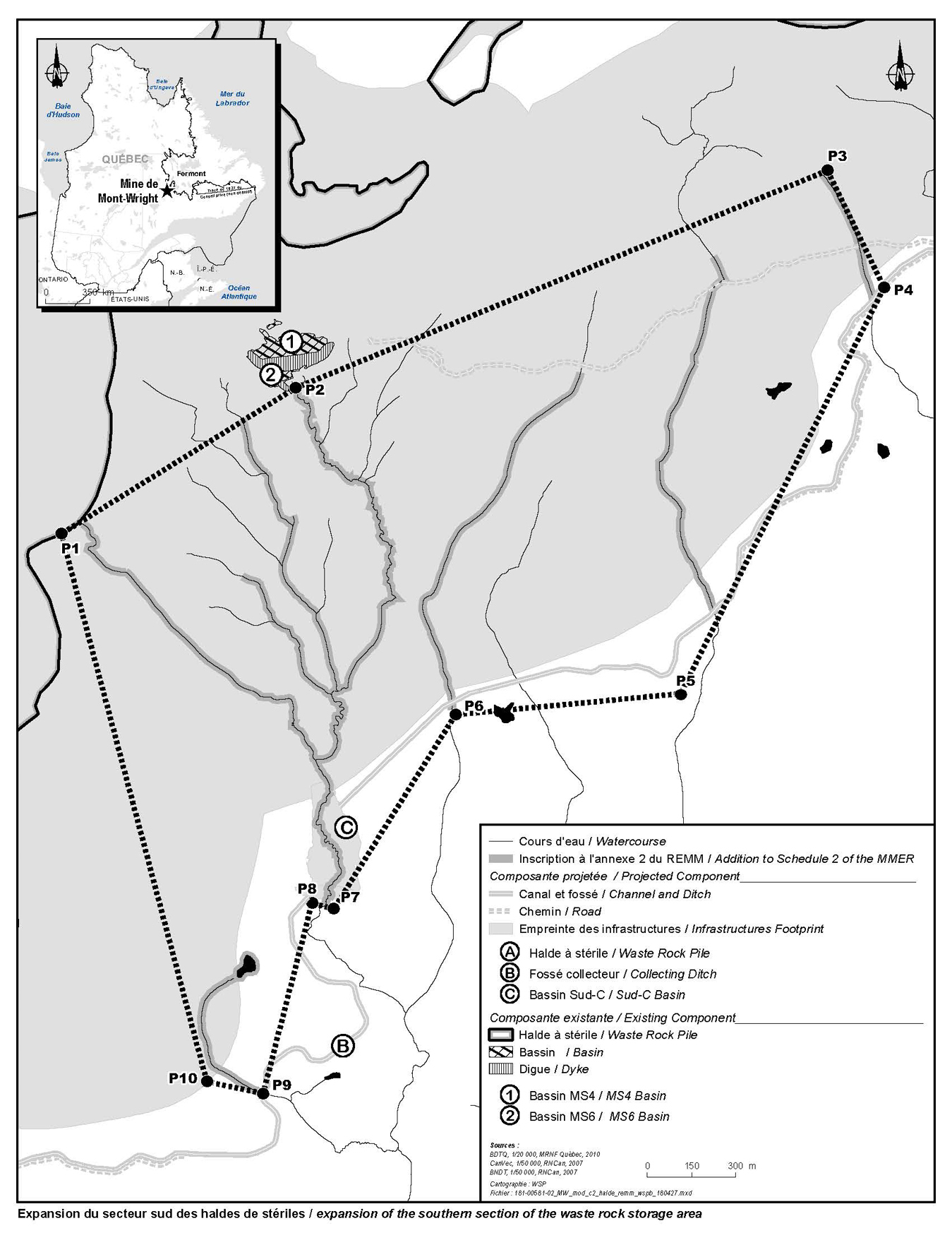
The regulatory amendments add water bodies frequented by fish and located within the areas, represented by polygons set out in Figures 1 and 2 herein, to Schedule 2 of the Regulations. These water bodies are located in the Pékans River watershed, approximately 15 km west of Fermont, Quebec. The expansion of the Hesse Tailing Pond and the waste rock pile sector will encroach on a total surface area of 63.9 ha of fish habitat.
Figure 1. Expansion of the Hesse Tailing Pond
All water bodies frequented by fish identified in grey and located within the polygon defined by 12 points, footnote 7 as well as part of a channel between points 10 and 11.
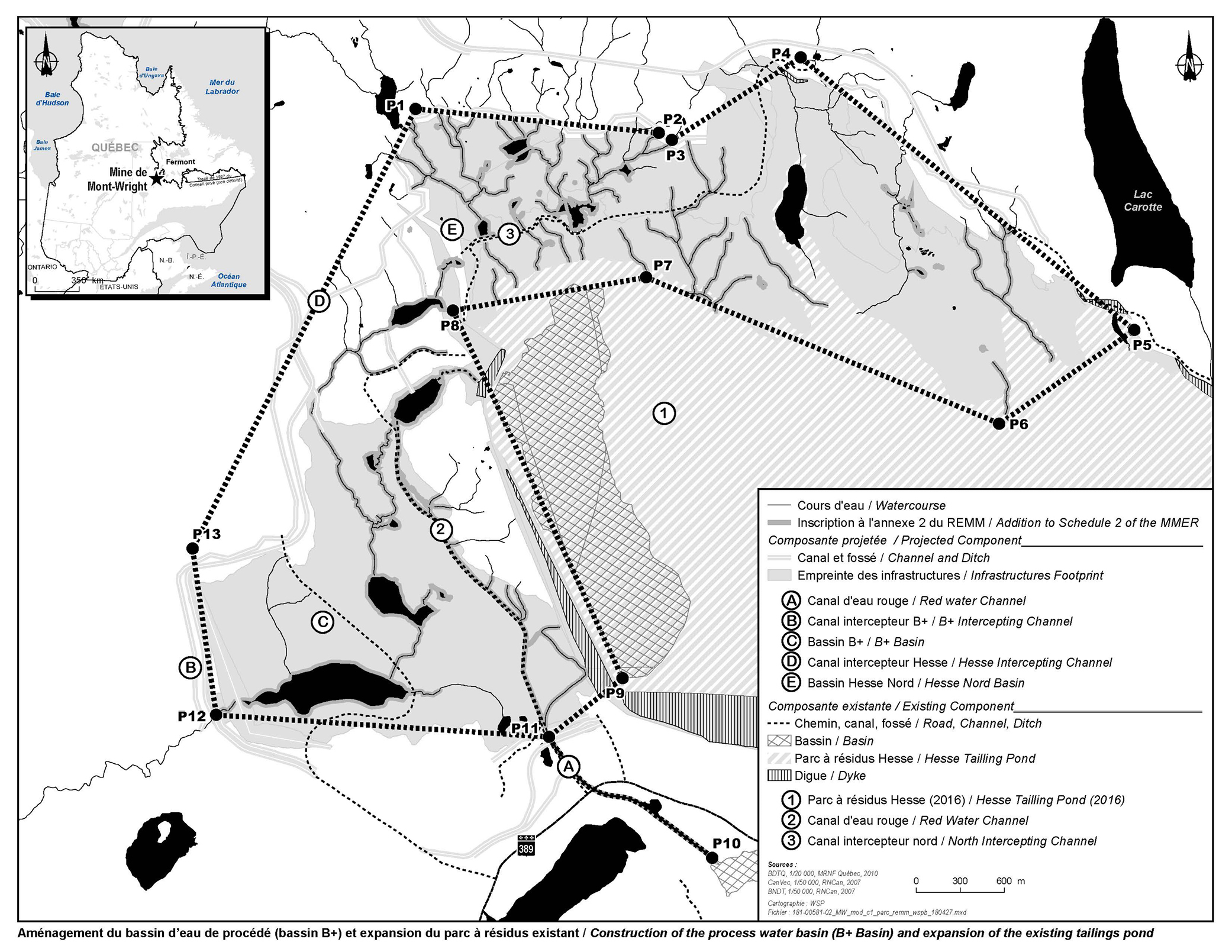
Figure 2. Expansion of waste rock pile sector
All of the water bodies frequented by fish identified in grey, located within the polygon below and defined by 10 points (P1-P10). footnote 8
Under section 27.1 of the Regulations, the proponent (and any future owner or operator) must implement a compensation plan to offset the loss of fish habitat resulting from the deposit of tailings into these water bodies. This plan must be approved by the Minister of the Environment. Moreover, the proponent is required to submit an irrevocable letter of credit to ensure that funds are in place should the owner or operator fail to address all the elements of the fish habitat compensation plan.
Fish habitat compensation plan
The compensation plan to offset the loss of fish habitat will be an environmental benefit once implemented, because the quality of the fish habitat will increase. The fish habitat compensation plan was reviewed and accepted by the Department of Fisheries and Oceans. The area covered by the plan is located on the north shore of the former Jeannine Lake Mine site, located approximately 160 km from Fermont and approximately 7 km southeast of the former town of Gagnon. More specifically, it consists of the tailings impoundment area of the former mining site plus two watercourses (an outlet of Jeannine Lake and a watercourse connected to the outlet).
The full concept proposed for the Jeannine Lake mining site involves a global approach to restore the tailings impoundment area to offset the losses of fish habitat and wetlands associated with the Mont-Wright project. The proposed work will be limited to the area between the mining site and Regional Road 389. The objectives of the project are the following:
- to stabilize the tailings impoundment area of the former Jeannine Lake mine to prevent the iron mine tailings from continuing to erode and migrate toward neighbouring water bodies;
- to restore the habitat in the outlet of Jeannine Lake and raise the water level in the series of lakes downstream of the pond, first to allow for passability by the fish and also to be able to recreate stable and productive ecosystems through the restoration of aquatic habitats and wetlands;
- to create a large body of water for brook trout; and
- to promote the establishment and maintenance of a population of brook trout through the development of a breeding ground for that species.
The implementation of these measures, whose costs are estimated, will allow for a direct gain of 74.55 ha of fish habitat to offset losses associated with the disposal of tailings and waste rock.
Regulatory and non-regulatory options considered
Non-regulatory options would involve the disposal of tailings in a manner that would not impact fish-frequented water bodies, or land-based options. Regulatory options correspond to those that would result in the destruction of waters frequented by fish.
AMEM prepared two alternative assessment reports to determine the best option for (1) tailings disposal; and (2) waste rock disposal. These assessments take into account the environmental, technical, economic and socio-economic impacts. The reports, entitled “Projet 2045, Mine de Mont-Wright: Évaluation des solutions de rechange pour l’entreposage des déchets miniers – septembre 2017” and “Aménagement de nouvelles haldes au sud de la fosse du Mont-Wright footnote 9 Évaluation de solutions de rechange – octobre 2017,” were released in January 2018, during the public consultations on the proposed amendments. Summaries of the reports were also prepared by AMEM. These assessments were conducted in accordance with the Department of the Environment’s Guidelines for the assessment of alternatives for mine waste disposal.
Alternatives to the expansion of the Hesse Tailing Pond and the construction of the process water basin (B+ Basin)
AMEM identified 10 potential options for the disposal of tailings from the expansion and development of the tailings impoundment area, including a land-based option (Option 0); all are sites where the disposal of tailings would not directly impact fish-frequented water bodies. Table 1 below sets out a summary of the options identified.
Note that for Options 1 to 7, the proposal is to optimize the footprint of the existing tailings impoundment area (Hesse Tailing Pond) toward the north until 2026 and to build a dyke north of the tailings impoundment area, a new clean-water intercepting channel and a new process water basin.
Table 1. Options studied with respect to the expansion of the Hesse Tailing Pond and construction of the B+ Basin
| Option |
Description |
|---|---|
Option 0 |
Land-based option: construction of a process water basin and several tailings impoundment areas with settling basins and water management systems (non-regulatory option). |
Option 1 |
Maximization of the expansion of the Hesse Tailing Pond toward the south. Partial filling of the Hesse Centre basin, construction of a 100-m high dyke, relocation of Route 389 and the rail line, process water-pumping station and increase in capacity of the process water basin. |
Option 2 |
Construction of a new mixed tailings pond to the northwest: construction of a water retention dyke, a decant structure, a settling basin and several containment dykes northeast of the existing tailings impoundment area. Increase in capacity of process water basin. |
Option 3 |
Construction of a new mixed tailings pond to the south and a new process water basin to the north of De La Rue Lake and Saint-Ange Lake retained by dykes and dams to the south and up against the natural topography to the north. Construction of a pipeline along Webb Lake to transport tailings from the concentrator to the tailings impoundment area. |
Option 4 |
Construction of a new mixed tailings pond to the south and a new process water basin to the north of De La Rue Lake and Saint-Ange Lake with a reduced footprint. New mine effluent in Saint-Ange Lake. |
Option 5 |
Spatial segregation of fine and coarse fractions. Disposal of coarse tailings within the existing footprint of the Hesse Tailing Pond and the construction of a new tailings impoundment area south of Webb Lake, east of the Pékans River and northwest of Saint-Ange Lake. Construction of new mine effluent in Saint-Ange Lake. |
Option 6 |
Installation of a filtration plant for the drying of tailings, construction of a conveyor to transport tailings to the Hesse Tailing Pond. |
Option 7 |
Spatial segregation of fine and coarse fractions. Disposal of coarse tailings within the footprint of the Hesse Tailing Pond and the construction of a tailings impoundment area with a smaller footprint northwest of the Hesse Tailing Pond for the disposal of fine tailings (increase in capacity of process water basin). |
Option 8 |
Construction of pipelines for disposal of tailings and collection of pulp water. |
Option 9 |
Construction of dykes at the outlet of selected lakes of significant size, construction of pipelines for the disposal of tailings, and the construction of settling basins and plants for treatment of water prior to release. |
Following the preselection stage, 5 of the 10 variations or options were rejected (Options 0, 1, 6, 8 and 9), because they did not allow for effective water resource management, were not profitable or were technologically risky from an environmental or technical perspective. The five other variations were analyzed in greater detail and presentations on them were made to the following groups: the Innu community of Uashat mak Mani-Utenam, Innu users of the territory, cottagers, and socio-economic representatives of Fermont. This exercise generated comments regarding the various options being considered. It became apparent that the variations focusing on the area south of the mine (Options 3, 4 and 5) near De La Rue Lake, Saint-Ange Lake and Pékans River, were of considerably less interest than the variations focusing on the area to the north (Options 2 and 7), which allowed for regional mining activities to be concentrated in a single area and to be at a greater distance from sensitive environments.
The information gathered allowed for an adjustment of the analysis and a comparison of the alternatives based on four main categories (environmental, technical, socio-economic and economic), 25 subcategories and 65 indicators. Option 7 obtained the highest merit score following this process. This alternative is a hybrid of Option 2 (favoured for its location far from sensitive environments and its gravity-based water return) and Option 5 (favoured for its reduced footprint through the segregation of fine and coarse tailings). Moreover, the location and the smaller footprint of Option 7 were preferred by the consulted stakeholders from the Innu community of Takuaikan Uashat mak Mani-Utenam and by the cottagers.
The variations were then subjected to a sensitivity analysis for the purpose of testing the robustness of the baseline assessment, performed with the assistance of expert opinions in the various areas investigated. Following this process, Option 7 obtained the highest score. AMEM determined that alternative 7, which involves the stacking of coarse tailings in the area above the existing Hesse Tailing Pond and the construction of a new tailings impoundment area to the northwest, represents the best option from an environmental, technical and socio-economic perspective for disposing of the tailings from now until the end of the Mont-Wright Mine’s lifespan.
Alternatives to the expansion of the waste rock piles
Three options meeting the above-mentioned baseline criteria were identified and are described in Table 2. These three options are regulatory options. No non-regulatory options that did not impact fish habitat were identified.
Table 2. Options studied with respect to the expansion of the waste rock pile sector
| Option |
Description |
|---|---|
1 |
New waste rock piles south of the pit that would allow for the disposal of a maximum of 2,035 Mt of waste rock over a surface area of 17 km2. This would be surrounded by a 16.7-km ditch. There would be two effluents, four water holding ponds and two water treatment plants. |
2 |
New waste rock piles on the south side of the pit that would allow for the disposal of 2,801 Mt of waste rock over a surface area of 19.2 km2. This would be surrounded by a 17.4-km ditch. There would be one effluent, three water holding ponds and one water treatment plant. |
3 |
Gradual filling of three existing pits to store up to 490 Mt of waste rock. Water would be managed through the use of pumps that would send the water to an existing process water basin. |
These three options were studied to determine whether there were unfavourable conditions or obstructions to their use for the disposal of waste rock. The preselection criteria used to study the three options were the following:
- (1) The site option has the necessary capacity for the disposal of the waste rock.
- (2) The site option would not prevent the potential development of a mining resource or the effective operation of the existing mine.
- (3) The option would allow for effective water management and an acceptable level of safety.
- (4) The option would not generate costs that could compromise the project’s feasibility.
Following the analysis of these four criteria, only Options 1 and 2 were retained and subjected to a detailed characterization. The parameters retained for this characterization fall into four broad categories of factors: environmental, technical, economic and socio-economic.
The environmental indicators include dust emissions (air quality); surface water reduction; potential for groundwater discharge on the boundaries of the infrastructure; impact on fish habitat surface area; effects downstream from the effluent; and impact on wetlands.
The technical indicators used include the expansion capacity of the waste rock piles; the number of additional water treatment plants; and the complexity of construction of the impermeable dykes and water management.
The economic and socio-economic indicators used include the impact on the water quality of the Pékans River and the use of the territory by the First Nations; the impact on fishing areas and the snowmobile trail (use of the territory by cottagers); cost of fish habitat compensation; and overall operating costs.
Following this analysis, Option 2 was selected as the best option from an environmental, technical, economic and socio-economic perspective.
Benefits and costs
Analytical framework
The regulatory amendments allow for the listing of fish-frequented water bodies in Schedule 2 of the Regulations, so that AMEM may use them for the disposal of tailings and waste rock.
Although cost impacts of the regulatory amendments are known and monetized, benefit impacts are not quantifiable, given the absence of a technically feasible, non-regulatory option for tailings disposal, and as such, a meaningful baseline scenario could not be created. As a result, the cost-benefit analysis reflects monetized costs and qualitatively described impacts.
The analysis below examines the impacts of the regulatory amendments on the environment, government, and Canadian businesses.
Environmental impacts
The selected alternatives impact fish-frequented water bodies that serve as a habitat to several species of fish: primarily brook trout, northern pike, longnose sucker, white sucker, burbot, mottled sculpin, pearl dace, lake chub and longnose dace. These species are of importance for recreational or Indigenous fishing or support such fisheries.
The expansion of the Hesse Tailing Pond, which includes the construction of the B+ Basin, encroaches upon several water bodies, the three largest of which are lakes covering a surface area of 35.6 ha and representing 57% of the total expected losses. However, field surveys have demonstrated that these water bodies were habitats with limited potential as fish habitat. The test fisheries conducted on these water bodies revealed very low fish populations, and brook trout in particular were absent from these lakes. Moreover, nearly 4.5 ha comprise the existing red water channel, an artificial structure of poor quality; 5.2 ha are habitats considered to be of low quality (marginal habitat, underground, presence of peat, partial or complete freeze in the winter, absence of brook trout) and 2.2 ha represent low-productivity peat bogs. For the other watercourses and water bodies, in most of the lost habitat, about 15 ha, the presence of brook trout has been confirmed or is suspected. Habitat quality varies from poor to good.
The expansion of the waste rock pile sector impacts several small water bodies totalling 1.442 ha of fish habitat. The watercourses south of the waste rock piles are small (with average widths varying from 3 m to less than 1 m) and several are of lower quality because of the presence of waste rock piles upstream (presence of algae and fine particles). Despite this, some watercourses nevertheless provide a good habitat for brook trout, and there are potential spawning grounds in various locations. Other watercourses have several underground sections that limit their usefulness to fish. There is also a shallow pond with an underground connection to a watercourse, limiting potential exchanges with the rest of the water system. The species of fish present in these water bodies are brook trout, longnose sucker and mottled sculpin. Burbot, lake chub and longnose dace may also frequent these waters because they are present upstream from the sector being added.
The loss of fish habitat corresponding to the disposal of tailings and waste rock represents 63.9 ha.
The loss of fish habitat would be offset by the implementation of the fish habitat compensation plan, as required under section 27.1 of the Regulations. The implementation of the compensatory measures would result in a direct gain of 74.55 ha of fish habitat and would offset the losses generated by the disposal of tailings and waste rock.
Following its evaluation, the Department of Fisheries and Oceans determined that the compensation plan proposed by AMEM to offset the loss of fish habitat that would result from the disposal of tailings and waste rock is relevant and that it complies with the guiding principles set out in its Fisheries Productivity Investment Policy: A Proponent’s Guide to Offsetting.
Social impacts
The location proposed for the disposal of tailings and waste rock is within the traditional territory (Nitassinan) asserted by the Innu communities of Uashat mak Mani-Utenam and Matimekush-Lac John and could therefore have impacts on the traditional activities of these communities, especially trapping.
During the consultation process led by AMEM regarding the study of various options for the disposal of tailings, the Innu community of Uashat mak Mani-Utenam expressed concerns regarding the preservation of the quality of the water of the Pékans River, in which fishing occurs and which is a tributary of the Moisie River, an important salmon habitat.
In the analysis of the various options for the disposal of tailings, trapping was considered a reliable indicator of the use of the territory, given the importance of this method of procurement to Indigenous culture. The option selected for the disposal of tailings was the one with the smallest impact, in terms of surface area, on traditional trapping areas. This option was also favoured by the Innu communities and cottagers because it was further from the Pékans River.
The Innu community of Uashat mak Mani-Utenam indicated that it was satisfied with the proposed location for the tailings impoundment area and the manner in which their concerns and interests influenced the selected option.
The Innu Nation of Matimekush-Lac John (INMLJ) submitted comments regarding the regulatory amendments and more specifically, on the fish habitat compensation plan. Other concerns related to social issues of importance to the INMLJ were also raised but go beyond the scope of the regulatory amendments.
The comments from the INMLJ are described in more detail under the “Consultation” section of this document.
Cost to business
The regulatory amendments will generate additional costs to AMEM because of the implementation of the compensation plan to offset the loss of fish habitat associated with the disposal of tailings and waste rock. The cost of implementing the compensation plan is estimated at about $14,000,000. footnote 10
The table below describes the estimated costs associated with the implementation of the compensation plan. footnote 11
Table 3. Proposed Schedule for Completion of the Compensation Program
| Description |
Undiscounted amount in 2018 Canadian dollars |
Amount discounted at a discount rate of 3% |
Proposed schedule |
|---|---|---|---|
Reprofiling/management of Jeannine Lake outlet and management of spawning grounds |
$2,200,000 |
$2,168,000 |
2018-2019 |
Construction of 18 crests, management of spawning grounds and construction of dykes and a fish ladder |
$9,600,000 |
$8,729,000 |
2019-2023 |
Management of spawning grounds / transfer of fish to new lake |
$100,000 |
$81,000 |
2023-2025 |
Monitoring program, including baseline conditions |
$1,200,000 |
$893,000 |
2018-2038 |
Total (including 20% contingency) |
$15,720,000 |
$13,939,000 |
Cost to government
Enforcement activities include inspections to monitor the implementation of the fish habitat compensation plan, which may incur incremental costs for the Government of Canada. Specifically, the need for monitoring and the number of site visits may increase, and there may be incremental monitoring costs incurred by the Department of Fisheries and Oceans. The incremental costs will not be high, given that the Department of Fisheries and Oceans plans to undertake one or more site visits and to monitor other authorizations under the Fisheries Act. Furthermore, these additional monitoring activities will occur during fish habitat compensation plan implementation and will not continue throughout the lifespan of the tailings and waste rock storage area.
Cost-benefit statement
Reference year |
... |
Final year |
Total (PV) |
Annualized average |
||
|---|---|---|---|---|---|---|
Quantified impacts (2018 price level / in constant millions of dollars) |
||||||
Costs |
AMEM |
2018 |
|
2038 | 14 |
0.9 |
Net benefits |
||||||
B. Quantified impacts in non-$ (e.g. from a risk assessment) |
||||||
Positive impacts |
Indigenous peoples, the general public |
The loss of fish habitat associated with the disposal of tailings and waste rock will be offset by |
||||
Negative impacts |
Indigenous peoples, the general public |
The loss of fish habitat associated with the disposal of tailings and waste rock amounts to |
||||
C. Qualitative impacts |
||||||
In terms of quality, most of the fish habitat to be destroyed by the mining activities is in marginal (but nevertheless important) areas and the loss will be offset by significant gains in fish habitat generated by the implementation of the compensation plan proposed by AMEM, i.e. the compensation project at the former Jeannine Lake Mine. The regulatory amendments to Schedule 2 will enable AMEM to continue its activities in compliance with the Act and the Regulations. The continuity of the mining operations will have positive impacts on employment and economic development. |
||||||
Strategic environmental assessment
A strategic environmental assessment concluded that authorizing the disposal of tailings in a tailings impoundment area will have adverse environmental effects, namely, the loss of fish habitat. However, the adverse environmental effects will be offset by the implementation of a fish habitat compensation plan that will result in no net loss of fish habitat. The proponents must also submit an irrevocable letter of credit covering the implementation costs of the plan, including the costs of any corrective measures necessary if the objective of the plan is not achieved.
“One-for-One” Rule
The “One-for-One” Rule does not apply to the proposed regulatory amendments, as there is no change in the administrative costs imposed on business.
Small business lens
The regulatory amendments do not trigger the small business lens, as AMEM, the owner and operator of the Mont-Wright Mining Project, is not considered a small business.
Consultation
The Department of the Environment held a public consultation session on January 25, 2018, in Fermont, Quebec. The purpose of this consultation was to allow members of the public and Indigenous groups to comment on the proposed alternatives for the disposal of tailings and waste rock and on the proposed compensation plan to offset the loss of fish habitat.
Only three people attended the public consultation session: two residents and the mayor of the Town of Fermont. One resident asked questions about the regulatory amendment process and stated that he had expressed his concerns during the public consultation process organized by the Quebec government’s Bureau d’audiences publiques sur l’environnement (BAPE). Another resident expressed his concerns about the environmental impact of the mines in his region, including the deterioration of water resources. AMEM explained the alternatives analysis and the mitigation measures undertaken by the company.
The Department of the Environment also consulted on the possibility of applying the policy on Streamlining the Approvals Process for Metal Mines with Tailings Impoundment Areas for the purpose of streamlining timelines for Governor in Council decisions for authorizing the proposed regulatory amendments. During this period, only the Mayor of the Town of Fermont and the Innu Takuaikan Uashat mak Mani-Utenam First Nation (ITUM) submitted written comments to the Department of the Environment.
In his letter, the mayor of the Town of Fermont indicated that the Town and its residents supported the project and the continuation of mining activities in the region. He also indicated the Town’s support for the “streamlining” process to allow for the water bodies to be listed more quickly, given the construction timelines for the expansion project.
ITUM also submitted a letter stating that the ITUM Band Council had been sufficiently consulted by AMEM during the process of adding the water bodies to Schedule 2 of the Regulations and that it did not consider it necessary to participate in the local consultations held in Fermont. ITUM also indicated its agreement with the streamlining policy to accelerate the listing process. ITUM also expressed its support for the Jeannine Lake compensation plan proposed by AMEM.
In 2012, AMEM and ITUM entered into an Impacts and Benefits Agreement (IBA) relating to the company’s projects. It is a multi-component agreement, under which ITUM has given its consent and support to the projects and ensured its full participation in them.
An environmental working group was set up under this agreement, and AMEM held meetings with ITUM regarding the project to expand the TIA for the Mont-Wright Mine.
The Department of the Environment also organized a public consultation session by teleconference to which national Indigenous and environmental organizations and representatives of the mining industry and the provincial government were invited. This teleconference was cancelled for lack of participation.
From August 14 to 16, 2018, representatives of Department of the Environment, the Department of Fisheries and Oceans and AMEM held meetings with the Council of the INMLJ. The purpose of these meetings was to explain to the members of the Council the regulatory amendment process and to present the alternatives report and compensation plan prepared by AMEM and to seek their comments.
Following the discussions with representatives of the Department of the Environment, the members of the INMLJ Council applied for funding to study the proposed regulatory amendments, in particular with respect to the alternatives analysis and the compensation plan. On October 26, 2018, the INMLJ Council presented a submission to the Department of the Environment with comments on the regulatory amendments. In its submission, the INMLJ Council notes that the existing Impact Benefit Agreement (IBA) between ITUM, AMEM and the INMLJ only covers the financial aspects of the relationship between the bands and AMEM, but that it lacks non-financial compensation. AMEM has indicated that it is committed to working with the INMLJ to address these additional concerns within the existing IBA.
With regards to the compensation plan, the INMLJ submitted comments on the different phases of the plan, which are described below. The responses to these comments are also provided below.
(1) Initial phase: Stabilization and revegetation of the tailings impoundment area
INMLJ comment: The rockfill should have a good waterproofing capacity in order to be able to contain the red sediments, especially during the spring freshet or during periods of strong hydropower. This rockfill must be supervised and a member of the Matimekush-Lac John First Nation shall be required to attend.
Department of the Environment response: AMEM has advised Department of the Environment officials that it is in agreement with having observers from the INMLJ present. In the Lac Jeannine sector, as in Mont-Wright, tailings do not have the characteristic red colouring observed in the ore deposits of Schefferville. The water that is present in the mine waste has a red colour because of the fine iron particles that could not be recovered by the ore concentration process and which oxidize, resulting in the red colour of the water. At the Lac Jeannine orphan site, there is no longer red water. Tailings, mainly composed of silica (gray sand), do not create colour in the natural environment. The shoreline will consist of granular material with a grain size distribution of 0 to 600 mm so as to ensure a seal with a rockfill (300–600 mm) to avoid erosion and retain the embankment.
INMLJ comment: Revegetation experiences elsewhere in former mining sites at these latitudes show a slow recovery often spread over several decades. It will be necessary to ensure that this initial phase fulfills its role, otherwise the particles from the old piles will continue to be carried downstream as is currently observed in Elross Creek within the Tata Steel iron mine of Tata Steel Minerals Canada. It is due to these past experiences that the Matimekush-Lac John First Nation insists on the presence of an Innu observer and this request is legitimate in the circumstances.
Department of the Environment response: AMEM has advised Department of the Environment officials that it is in agreement with having observers from the INMLJ present. AMEM added that a sector of the Jeannine Lake Tailings Park had undergone successful revegetation trials in the 1980s. In addition, revegetation has also occurred and continues to occur at the Mont-Wright tailings impoundment area. This work, which is located a little further north of the former Lac Jeannine Park, has been successful.
(2) Phase 2: Construction of crests
INMLJ comment: Since the construction of these crests aims at revitalizing brook trout populations, portage trails should be included around these crests to ensure that this entire hydrographic network is accessible to fishermen. These trails should be primarily accessible to affected First Nations in order to limit the anticipated opening of the territory to non-Indigenous peoples.
Department of the Environment response: AMEM has advised Department of the Environment officials that access roads that would have to be built to allow the construction of required infrastructure for trails would make the network accessible by users of the territory. However, since the work and activities would be done on Crown lands, authority to allow the use of the trails would rest with the Government of Quebec.
INMLJ comment: We agree that the construction of the crests should be completed only once the impoundments are constructed and the sediment dynamics of the site are stabilized. If necessary, additional efforts must be made to obtain this result before proceeding with setting up the spawning grounds. Otherwise, there is a high risk that these spawning grounds will be covered with fine sediments and will never become effective. It is on these conditions that the INMLJ will be able to approve the project. We note that such developments will add an additional function to the habitat because no brook trout breeding grounds have been identified downstream of the mine site to date. For the INMLJ, this is a significant gain for this species in the context of this project and we will pay particular attention to the success, functionality and performance of these developments in terms of reproductive success of the species (number of eggs deposited / number of fry produced). AMEM will have to finance periodic and timely inspections of these by members of the INMLJ.
Department of the Environment response: Under the compensation plan, the required follow-ups will make it possible to determine the effectiveness of the measures put in place to stabilize the tailings pond and to slow down the new sedimentary inputs. AMEM can only carry out subsequent stages of the compensation plan if the results of the follow-ups are satisfactory. If failures are identified during the monitoring program implemented by AMEM, these will need to be corrected as required under the Regulations. To secure AMEM’s compliance with the compensation plan, the Department of Fisheries and Oceans holds an irrevocable letter of credit as required under the Regulations.
During AMEM’s meetings with the Council of the INMLJ, AMEM indicated its commitment to involve the community in the follow-up and will therefore be able to engage the INMLJ to join the monitoring process of the fish management activities.
(3) Phase 3: Creation of a lake of approximately 70 ha and construction of dykes
INMLJ comment: it is clear to the INMLJ that its members must be involved in the implementation of these works, whether through employment or continuous consultation, the scheduling of such works and through the follow-up activities.
In addition, INMLJ agrees with the caution expressed by the proponent regarding the development of brook trout spawning grounds. Thus, INMLJ agrees that studies be conducted at least two years after impoundment to determine the sites that offer the best potential for developing efficient spawning grounds for the brook trout. However, the minimum suggested area (50 m2) seems small; 100 m2 seems more appropriate.
Department of the Environment response: AMEM has advised Department of the Environment officials that it is committed to maintaining open consultation channels with the community and to integrate its members, as part of the socio-economic measures provided for in the IBA, during the works and monitoring of the compensation plan.
As indicated in the compensation plan, two years after impoundment, a detailed characterization of the new waterbody will identify the best potential sites for breeding. Once sites have been selected and approved by the Department of Fisheries and Oceans, a minimum spawning area of 50 m2 will be developed for brook trout. The Department of Fisheries and Oceans will be able to take into account the area proposed by the INMLJ following the characterization of the new water body. The final area developed for the spawning grounds will depend mainly on the facies of the stream that will be recreated. Thus, the potentially developable area will always be maximized according to the parameters of the watercourse.
Rationale
Section 36 of the Fisheries Act (FA) prohibits the deposit of deleterious substances in water frequented by fish, unless authorized by Regulations under the FA or another Act of Parliament. The Metal and Diamond Mining Effluent Regulations, made under subsection 36(5) of the FA, includes provisions permitting the use of water bodies frequented by fish for the disposal of tailings.
Non-regulatory options involve the disposal of tailings in a manner that would not directly impact fish-frequented water bodies, or land-based options. Regulatory options correspond to those that would result in the destruction of waters frequented by fish.
AMEM prepared two alternatives assessments to determine the best option from an environmental, technical, economic and socio-economic perspective. These assessments were conducted in accordance with the Department of the Environment’s Guidelines for the assessment of alternatives for mine waste disposal. The selected solutions impact fish-frequented water bodies. The regulatory amendment will list these water bodies in Schedule 2 of the Regulations, designating them as tailings impoundment areas, thereby allowing AMEM to dispose of tailings and waste rock there.
Given that the selected options will generate a loss of fish habitat, under section 27.1 of the Regulations, AMEM must implement a compensation plan to offset these losses. The implementation of these compensatory measures, the costs of which are estimated at $14,000,000, will allow for a direct gain of 74.55 ha of fish habitat, offsetting the losses generated by the disposal of tailings and waste rock. Under subsection 27.1(3), AMEM is required to submit an irrevocable letter of credit covering the value of the compensatory plan to ensure its implementation and the achievement of its compensatory objectives.
Implementation, enforcement and service standards
The regulatory amendments will enable AMEM to use fish-frequented water bodies for disposal of tailings and waste rock from the activities of the Mont-Wright Mine.
Given that the Regulations are made pursuant to the Fisheries Act, enforcement personnel would, when verifying compliance with the Regulations, act in accordance with the Compliance and enforcement policy for habitat and pollution provisions of Fisheries Act (the Policy). Verification of compliance with the Regulations and the Fisheries Act would include, among other inspection activities, site visits, sample analysis, review of fish habitat compensation plans and related reports associated with the proposed amendments.
If there is evidence of an alleged offence of the fisheries protection and pollution prevention provisions of the Fisheries Act and/or related regulations, enforcement personnel would determine an appropriate enforcement action, in accordance with the following criteria, as set out in the Policy:
- the nature of the alleged violation;
- effectiveness in achieving the desired result with the alleged violator; and
- consistency in enforcement.
Given the circumstances and subject to the exercise of enforcement and prosecutorial discretion, the following instruments are available to respond to alleged violations:
- warnings;
- directions;
- orders by the Minister;
- injunctions; and
- prosecutions.
For more information on the Policy, please consult the Compliance and enforcement policy for habitat and pollution provisions of Fisheries Act.
Contacts
Nancy Seymour
Manager
Mining Section
Mining and Processing Division
Industrial Sectors, Chemicals, and Waste Directorate
Department of the Environment
Email: ec.mmer-remm.ec@canada.ca
Matt Watkinson
Director
Regulatory Analysis and Valuation Division
Economic Analysis Directorate
Department of the Environment
Email: ec.darv-ravd.ec@canada.ca